|
Information about
Azad Jammu and Kashmir
|
|
|
Coordinates: 34.22°N 73.28°ECoordinates: 34.22°N 73.28°E
|
|
|
Established
|
1948
|
|
Capital
|
Muzaffarabad
|
|
Largest city
|
Mirpur
|
|
Government
|
|
|
• Type
|
Self-governing state under Pakistani federation
|
|
• Body
|
Legislative assembly
|
|
• President
|
Sardar
Muhammad Yaqoob Khan
|
|
• Prime Minister
|
Chaudhry
Abdul Majid
|
|
Area
|
|
|
• Total
|
13,297 km2 (5,134 sq mi)
|
|
Population (2008; est.)
|
|
|
• Total
|
4,567,982
|
|
• Density
|
340/km2 (890/sq mi)
|
|
Time zone
|
PKT (UTC+5)
|
|
ISO 3166 code
|
PK-JK
|
|
Main
Language(s)
|
·
Urdu (official)
·
Pahari
·
Mirpuri
·
Gojri
·
Hindko
·
Punjabi
·
Pashto
|
|
Assembly seats
|
49
|
|
Districts
|
10
|
|
Towns
|
19
|
|
Union Councils
|
182
|
|
Website
|
www.ajk.gov.pk
|

Azad Jammu and Kashmir Azad Jammu o Kashmir, abbreviated AJK) or, for short, Azad Kashmir (literally "Free
Kashmir") is the southernmost political entity within the Pakistani-controlled part of the
former princely state of Jammu and Kashmir. It borders Indian-Administered Jammu and Kashmir to the east (separated from
it by the Line of Control), Khyber
Pakhtunkhwa province to the west, Gilgit-Baltistan to the north, and the Punjab province to the south. With
its capital at Muzaffarabad, Azad Jammu and Kashmir
covers an area of 13,297 square kilometres (5,134 sq mi) and has an
estimated population of about four million.
Azad Jammu and Kashmir and Gilgit-Baltistan
together constitute the region referred to as "Pakistani-controlled
Kashmir" by the United Nations and other international
organisations and as "Pakistan-occupied Kashmir" in India, in contrast to the name
"Indian-occupied Kashmir", which is given by Pakistan to the Indian
state of Jammu and Kashmir. The territories have been under the control of the
two countries since theFirst
Kashmir war,
after which the area of Azad Jammu and Kashmir was successfully captured from
the princely state by rebelling militias with the help of the Pakistani Army.
History
: History
of Azad Kashmir
Further
information: History
of Kashmir

At the time of the Partition
of India in 1947, the British abandoned their suzerainty over the princely states, which were left with the
options of joining India or Pakistan or remaining independent. Hari Singh, themaharaja of Jammu and Kashmir,
wanted his state to remain independent. In order to buy some time, he signed a
stand-still agreement, which sidestepped the encouragement of the princely
states to join either India or Pakistan. Later, there was a
revolution by Muslims in the western part of the state, as raiders from what was
then the North-West Frontier Provinceand the tribal areas feared
that Hari Singh might accede to the Union of India. In October 1947, they
attacked Kashmir in an attempt to take control of the princely state.
Initially, Hari Singh tried to resist their progress but failed. He then
requested the military help of India, which responded that it would not help
him unless he acceded to India. On October 26, 1947, Hari Singh signed an Instrument of Accession, and Indian troops were
immediately airlifted into Srinagar. Pakistan intervened subsequently. Fighting ensued between the
Indian and Pakistani armies, with the two areas of control stabilized, more or
less, around what is now known as the "Line of Control".
Later, India approached the United Nations,
asking it to solve the dispute, and resolutions were passed in favour of the
holding of a plebiscite with regard to Kashmir's future. However, no such
plebiscite has ever been held on either side, since there was a precondition
which required the withdrawal of the Pakistani Army along with the non-state
elements and the subsequent partial withdrawal of the Indian Army. from the parts of Kashmir
under their respective control – a withdrawal that never took place.] In 1949, a cease-fire line
separating the Indian- and Pakistani-controlled parts of Kashmir was formally
put into effect.
Following the 1949 cease-fire agreement, the
government of Pakistan divided the northern and western parts of Kashmir which
it held into the following two separately-controlled political entities:
1. Azad Jammu and Kashmir
(AJK) – the narrow, southern part, 250 miles (400 km) long, with a width
varying from 10 to 40 miles (16 to 64 km).
2. Gilgit–Baltistan formerly called the Federally Administered Northern Areas (FANA) – the much larger
area to the north of AJK, 72,496 square kilometres (27,991 sq mi). It
was directly administered by Pakistan as a de facto dependent territory, i.e.,
a non-self-governing territory. However, it was ostensibly granted "full
autonomy" on August 29, 2009.
An area of Kashmir that was once under
Pakistani control is the Shaksgam
tract, a
small region along the northeastern border of Gilgit-Baltistan that was
provisionally ceded by Pakistan to the People's Republic of China in 1963 and
which now forms part of China'sXinjiang Uygur Autonomous Region.
In 1972, the then-current border between the
Indian- and Pakistani-controlled parts of Kashmir was designated as the "Line of Control". The Line of Control
has remained unchanged since the 1972 Simla Agreement, which bound the two
countries "to settle their differences by peaceful means through bilateral
negotiations". Some political experts claim that, in view of that pact,
the only solution to the issue is mutual negotiation between the two countries
without involving a third party such as the United Nations.
A
devastating earthquake hit Azad Kashmir in 2005.
Kashmir related holidays
Azad Kashmir Day is celebrated in Azad Jammu
and Kashmir on October 24, which is the day that the Azad Jammu and Kashmir
government was created in 1947. Pakistan has celebrated Kashmir
Solidarity Day on February 5 of each year since 1990 as a
day of protest against India's control of the major part of Jammu and Kashmir. That day is a national
holiday in Pakistan.
Government
Azad Jammu and Kashmir (AJK) is a
self-governing state under Pakistani control, but under Pakistan's constitution
the state is not actually part of Pakistan. Azad Kashmir has its own
elected president, prime minister, legislature, high court, and official flag.
The state has it own judiciary, as well, with Khawaja Shahad Ahmad as its
present chief justice. The government of Pakistan has not yet allowed Azad
Kashmir to issue its own postage stamps. Stamps of Pakistan are used, instead.
Azad Kashmir's financial matters, i.e.,
budget and tax affairs, are dealt with by the Azad Jammu and Kashmir Council
rather than by Pakistan's Central Board of Revenue. The Azad Jammu and Kashmir
Council is a supreme body consisting of 11 members, six from the government of
Azad Jammu and Kashmir and five from the government of Pakistan. Its
chairman/chief executive is the president of Pakistan. Other members of the
council are the president and the prime minister of Azad Kashmir and a few
other AJK ministers.
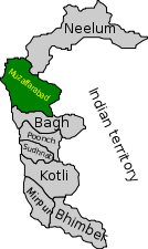
Administrative divisions
The state is administratively divided into
three divisions which, in turn, are divided into ten districts.
|
Division
|
District
|
Area (km²)
|
Population (1998)
|
Headquarters
|
|
Mirpur
|
Bhimber
|
1,516
|
301,633
|
Bhimber
|
|
Kotli
|
1,862
|
563,094
|
Kotli
|
|
|
Mirpur
|
1,010
|
333,482
|
Mirpur
|
|
|
Muzaffarabad
|
Muzaffarabad
|
2,496
|
638,973
|
Muzaffarabad
|
|
Hattian
|
?
|
?
|
Hattian Bala
|
|
|
Neelam
|
3,621
|
106,778
|
Athmuqam
|
|
|
Poonch
|
Poonch
|
855
|
411,035
|
Rawalakot
|
|
Haveli
|
600 (est.)
|
150,000 (est.)
|
Forward Kahuta
|
|
|
Bagh
|
768
|
243,415
|
Bagh
|
|
|
Sudhnati
|
569
|
334,091
|
Pallandari
|
|
|
AJK Total
|
10 districts
|
13,297
|
2,972,501
|
Muzaffarabad
|
Geography and climate
|
|
|
The northern part of Azad Jammu and Kashmir
encompasses the lower part of the Himalayas, including Jamgarh Peak
(15,531 feet [4,734 meters]). However, Hari Parbat peak in the Neelum Valley is the highest peak in the
state. Fertile, green, mountainous valleys are characteristic of Azad Kashmir's
geography, making it one of the most beautiful regions on the subcontinent.The region receives
rainfall in both winter and summer. Muzaffarabad and Pattan are among the
wettest areas of the state. Throughout most of the region, the average rainfall
exceeds 1400 mm, with the highest average rainfall occurring near Muzaffarabad
(around 1800 mm). During the summer season, monsoon floods of the Jhelum and Leepa rivers are common, due to high rainfall and
melting snow.
Tourist attractions
Azad Kashmir is the one of the most beautiful
regions in the world. It's sometimes referred to as "Heaven on Earth"
for its scenic beauty. Some well-known and popular tourist destinations are the
following.
·
Muzaffarabad, the capital city of Azad
Kashmir, is located on the banks of the Jhelum and Neelum rivers. It is 138
kilometres (86 mi) from Rawalpindi and Islamabad. Well-known tourist spots
near Muzaffarabad are the Red Fort, Pir Chinassi, Patika, andSubri Lake.
·
The Neelam Valley is situated to the north
and northeast of Muzaffarabad, The gateway to the valley. The main tourist
attractions in the valley are Athmuqam, Kutton, Keran, Kel, Sharda and Taobat.
·
Rawalakot city is the headquarters of
Poonch District and is located 122 kilometres (76 mi) from Islamabad.
Tourist attractions in Poonch District are Banjosa Lake, Devi Gali, Tatta Pani,
and Toli Pir.
·
Bagh city, the headquarters of
Bagh District, is 205 kilometres (127 mi) from Islamabad and 100
kilometres (62 mi) from Muzaffarabad. The principal tourist attractions in
Bagh District are Dhirkot, Sudhan Gali, Neela Butt, and Las Danna.
·
The Leepa Valley is located 105 kilometres
(65 mi) southeast of Muzaffarabad. It is the most charming and scenic
place for tourists in Azad Kashmir.
·
Mirpur city is the headquarters of
Mirpur District. The main tourist attractions near Mirpur city are the Mangla Lake and Ramkot Fort.
Culture
: Culture
of Kashmir
 The culture of Azad Kashmir has many
similarities to that of northern Punjabi (Potohar) culture in Punjab
province. The natives of Azad Kashmir speak Urdu, Potwari, and the Paharilanguages. The traditional
dress of Kashmiri women is the shalwar kameez in Pahari style. The
shalwar kameez is commonly worn by both men and women. Women use the Shawl orKashmir shawl to cover their head and
upper body.
The culture of Azad Kashmir has many
similarities to that of northern Punjabi (Potohar) culture in Punjab
province. The natives of Azad Kashmir speak Urdu, Potwari, and the Paharilanguages. The traditional
dress of Kashmiri women is the shalwar kameez in Pahari style. The
shalwar kameez is commonly worn by both men and women. Women use the Shawl orKashmir shawl to cover their head and
upper body.
The popular and traditional cuisines of Azad
Kashmir are Kashmiri Raan (Fried leg of lamb in Kashmiri style), Rogan Josh,
Balti Gosht, Kashmiri Dal Chawal (A mixture of split peas, split red lentils, and
boiled rice), and Dam Aloo (Fried Potatoes in Kashmiri style).
Ethnic groups
: Ethnic groups of Azad Kashmir
Azad Jammu and Kashmir is predominantly
Muslim. The majority of the population is culturally, linguistically, and
ethnically related to the people of northern Punjab. The article,Ethnic
groups of Azad Kashmir gives a breakdown of all the major tribes in
the state. The principal languages spoken are Pahari, Gojri, Dogri, Potohari, Urdu, Kashmiri, Pashto, andPunjabi.
A large number of residents of this area have
relatives who live in England. Mirpur, in particular, retains strong
links with the UK.
Languages
Urdu is the official language of Azad Jammu and
Kashmir. However, due to the area's diverse cultural
blend, many languages are spoken by different populations, including Pahari-Potwari, Hindko, Gojri, Punjabi and Pashto.
Economy and resources
: Economy
of Azad Kashmir
|
|
This section requires expansion. (June
2008)
|
In the mid-1950s various economic and social
development processes were launched in Azad Kashmir. In the 1960s, with the
construction of the Mangla Dam in Mirpur District, the Azad Jammu and
Kashmir Government began to receive royalties from the Pakistani government for
the electricity that the dam provided to Pakistan. During the mid-2000s, a
multi-billion dollar reconstruction began in the aftermath of the 2005
Kashmir earthquake.
Agriculture is a major part of Azad Kashmir's
economy. Low-lying areas that have high populations grow crops like barley, mangoes,millet, corn (maize), and wheat, and also raise cattle. In
the elevated areas that are less populated and more spread-out, forestry, corn,
and livestock are the main sources of income.
There are mineral and marble resources in
Azad Kashmir close to Mirpur and Muzaffarabad. There are also graphite
deposits at Mohriwali. There are also reservoirs of low-grade coal, chalk, bauxite, and zircon. Local household industries produce carved wooden
objects, textiles, and dhurrie carpets. There is also an arts and
crafts industry that produces such cultural goods as namdas, shawls, pashmina,
pherans, Papier-mâché, basketry copper, rugs,
wood carving, silk and woolen clothing, patto, carpets, namda gubba, and
silverware. Agricultural goods produced in the region include mushrooms, honey,
walnuts, apples, cherries, medicinal herbs and plants, resin, deodar, kail, chir,
fir, maple, and ash timber.
In addition to agriculture, textiles, and
arts and crafts, remittances have played a major role in the economy of Azad
Kashmir. One analyst estimated that the figure for Azad Kashmir was 25.1% in
2001. With regard to annual household income, people living in the higher areas
are more dependent on remittances than are those living in the lower areas.
In the latter part of 2006, billions of
dollars for development were mooted by international aid agencies for the reconstruction and rehabilitation of
earthquake-hit zones in Azad Kashmir, though much of that amount was
subsequently lost in bureaucratic channels, leading to considerable delays in
help getting to the most needy. Hundreds of people continued to live in tents
long after the earthquake. A land-use plan for the city of Muzaffarabad was prepared by the Japan international cooperation agency.
Remittances by British Pakistanis form an important part of the Kashmiri
economy.
Education
The literacy rate in Azad Kashmir was 62% in
2004, higher than in any region in Pakistan. However, only 2.2% were
graduates, compared to the average of 2.9% for Pakistan.
ton of informative material
ReplyDeletegood work keep it up ADMIN
superb man gud work move ahead..........dnt stop
ReplyDelete